
In the future, cities will face the challenge of optimising and digitally controlling their water supply. The Potsdam-based company Vragments is developing specific apps and augmented reality applications to take us on a virtual tour to the groundwater.
Water is the most common natural substance on the earth’s surface. The salt water of the world’s oceans accounts for 97.5 percent, the remaining percent are accounted for by soil moisture, groundwater, lakes and rivers, the atmosphere and living organisms. However, water does not disappear, but has been circulating in all kinds of cycles since time immemorial. In order to ensure our water supply, this cycle must be well organized, especially in urban centres. Yet, the water infrastructure of cities is usually almost completely hidden from us. Most of it takes place many metres below the earth’s surface and completely invisible to us. We turn on the tap and get our drinking water.
But how is the cities’ urban water supply organized? The centres are facing a challenge against the backdrop of climate change and population growth: new digital solutions are needed in order to install an intelligent water management system for the future in the cities.
The EU project digital-water.city (DWC, Grant Agreement No. 820954) is conducting research on this issue across Europe based on the examples of the five cities of Paris, Sofia, Copenhagen, Milan and Berlin. The project’s coordinator as well as initiator is the Kompetenzzentrum Wasser Berlin (KWB).
The tasks and solution approaches for digital-water.city are different in each city. In general, water companies supply households with drinking water, control quality of the water and sewer systems, clean, maintain and operate sewers, wastewater treatment and its reuse. They take action when sewers are overloaded or flooded and manage our wastewater treatment plants.
Work is underway within the Berlin project to optimise the maintenance of the drinking water wells and reduce mixed water overflows in Berlin’s sewer system – by using visualisation techniques such as augmented and mixed reality.
And this is where the start-up Vragments from the MediaTech Hub Lab comes into play. The company from Potsdam-Babelsberg is made up of a team of journalists, developers and storytellers who create augmented and virtual reality experiences. They are now working on two apps for digital-water.cities - one for the general population and the other for Berliner Wasserbetriebe and urban decision-makers.
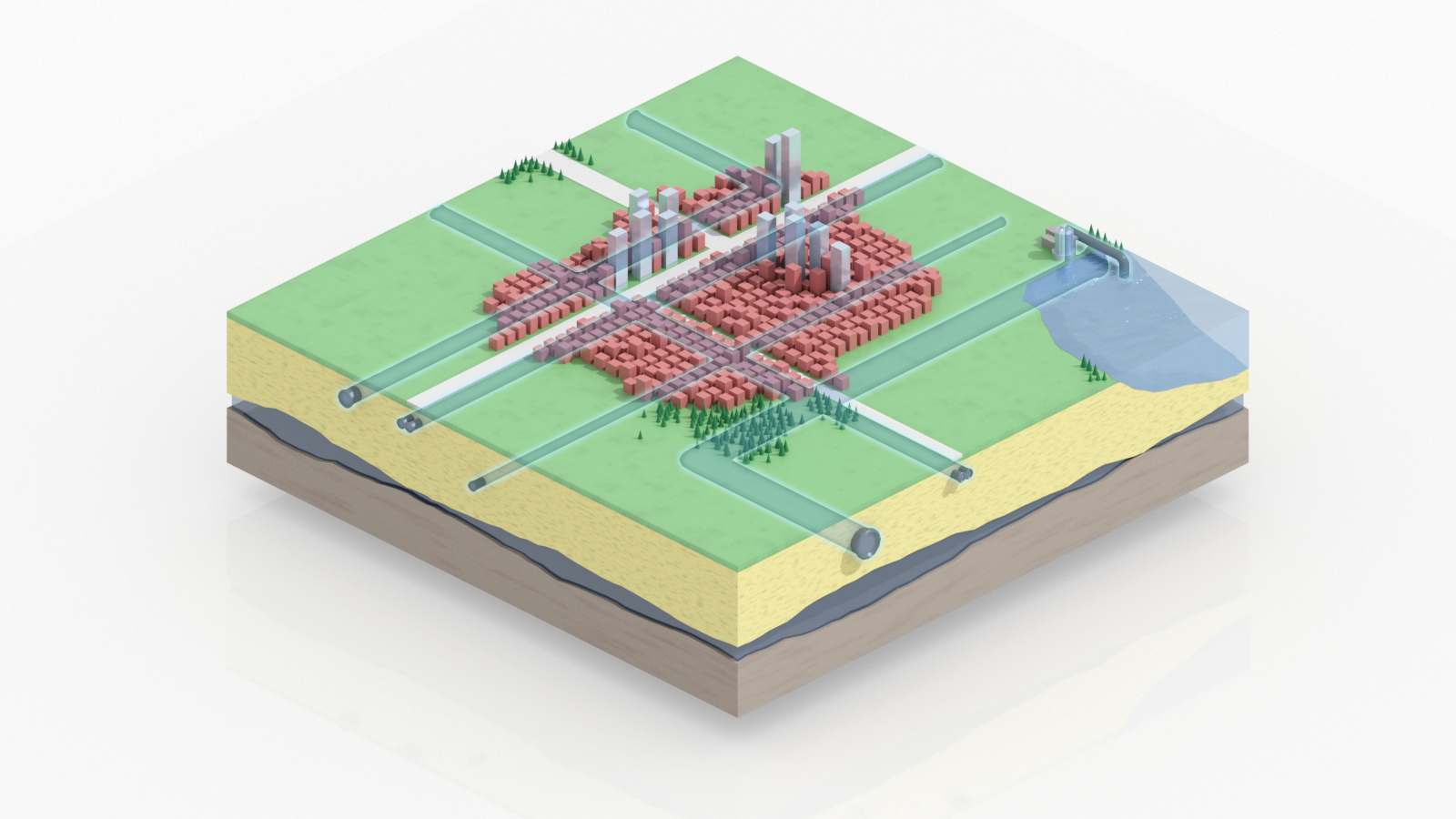
What is special about Berlin is that the water supply mainly comes from areas within the city and needs a high level of protection. The app for the population communicates how the drinking water cycle works. What happens in Berlin’s sewer system during heavy rainfall? How does bank filtration work at the Wannsee, for example? What processes the water goes through before it reaches the drinking water wells? Thanks to the visualisation of underground simulations in the app, users can look deep under the surface of the metropolis and follow the processes of water treatment. This is intended to sensitise citizens to the value of drinking water.
The second app which Vragments is currently working on is specifically designed for professional use and will support the maintenance work of water companies.
At present, drinking water wells are checked and maintained at statistically determined intervals, regardless of whether there is an actual need. Orders and documentation are usually paper-based processes where the water supply operators make a note on-site of the latest values or maintenance events, such as replacing a device , and record these later in the company’s databases. “With our app, we want to move away from calendar or time-based maintenance planning toward demand-oriented maintenance planning,” says Stephan Gensch, co-founder and Head of Product Development at Vragments. This works when data is collected and prepared quickly and effectively at a central location: “The app enables data to be made available more quickly and synchronised immediately without manual input when there is an Internet connection. This would save a lot of organisational outlay on maintenance in Berlin where there are about 650 active wells. Therefore, data and business processes of the various activities and main waterworks have to be collected in advance and prepared for practical deployment in the app.
Vragments is working directly with the Berliner Wasserbetriebe and the Kompetenzzentrum Wasser Berlin on the technical implementation of the geo-project. “Our team has experience in various sectors, from the banking sector through the gaming industry to geoinformatics, as well as technical expertise in data management and the development of high-performance backend and mobile frontend systems,” says Gensch. Vragments focuses on agile development and optimises the designs after regular feedback sessions with the stakeholders.
The biggest challenge here, apart from the scientific simulation, is the visualisation. Making water visually credible is particularly demanding. “Normally, you have something like three-dimensional raster maps with some scalar values. But that’s not something that laymen can understand. We’re opting instead for a visual experience.” Vragments has two scenarios here. On the one hand, the user can view a digital tabletop model of the surface and subsurface with its network of pipes, pumps, and channels, and, on the other hand, it will be possible to experience the environment and the underlying system virtually one-to-one - thanks to the VR app, the user will be able to look under the surface with x-ray vision. The smartphone and augmented reality will help open up Berlin’s subsurface through the various layers of sand, earth and rock to the groundwater for everybody. The complex processes of an urban water cycle will consequently be presented in a playful and engaging way, and there can be a better communication of the water utilities’s work. The app can also be used for school and teaching purposes. At present, this visualisation is only being planned for the Berlin area and supported within the framework of the EU project. It is conceivable that it could also be implemented for other cities at a later date.
By Christine Lentz
Read more blog articles here.
About MTH Blog
The media technologies of the future are already being used today – not only in the entertainment sector, but also in a wide variety of industries. Christine Lentz meets up with tech enthusiasts, established companies and researchers for our monthly MediaTech Hub Potsdam blog to tell the stories behind the innovative business models.